Appendix 2 – Economic Appendix
This appendix presents the economic analysis for proposed modifications to the Sabine-Neches Waterway (SNWW). The SNWW project area and the general boundaries of its channel reaches are shown on Figure 1. The existing project is defined by a 40-foot project depth from the Gulf of Mexico offshore entrance channel to Port Arthur and Beaumont and a 30-foot project depth to the Port of Orange. Project alternatives were evaluated based on reductions in transportation costs generated from more-efficient vessel loading and from reductions in vessel delays due to channel deepening and widening. The benefits were calculated for a 2019–2069 period of analysis using Fiscal Year (FY) 2009 Federal Discount rate of 4.375 percent and the deep-draft vessel operating costs contained in the unpublished update to Economic Guidance Memorandum (EGM 08-04). The deepening benefits were calculated using a Microsoft Excel spreadsheet model. The widening benefits were calculated using the HarborSym model. The analyses and computations presented in this appendix are based on data and statistics obtained from personal interviews with industry officials and from analyses of historical data and published trends.
The appendix contains nine sections. This first section presents general information on channel use and the results of the initial screening, and an overview of the historical traffic base. Section 2 presents an evaluation of the major commodity groups. Section 3 presents the existing vessel utilization trend data and a casualty assessment. Section 4 presents the commodity and fleet forecasts. Section 5 summarizes total tonnage. Section 6 presents the transportation savings benefit analysis. Section 7 presents a summary of the project benefits and incremental analysis. Section 8 presents the sensitivity analyses. Section 9 presents an overview of regional economics.
The SNWW terminals include the public marine facilities owned by the ports of Beaumont, Port Arthur, and Orange, as well as the petroleum refineries, chemical plants, and general cargo terminals. Vessels and barges are used to transport crude oil, petroleum products, liquid and dry chemicals, and steel and dry bulk cargo. Deep-draft cargoes are transported from offshore through the Sabine Pass Channel. The Port of Port Arthur’s general cargo facilities are located on the Sabine-Neches Canal near mile 32, and its crude petroleum and product terminals are in the Taylor Bayou basin. The Port of Beaumont’s public and private docks are located on the Neches River Channel. The Channel to Orange intersects with the Gulf Intracoastal Waterway (GIWW) at the east end of the SNWW. Improvements to the Channel to Orange were not evaluated due to the expectation of low utilization of the existing project depth. In addition to its large volume of deep-draft traffic, the Sabine-Neches Canal serves as a through channel for the GIWW. The GIWW extends from Apalachee Bay, Florida, to Brownsville, Texas, and connects with the SNWW at approximately 3 miles below Orange and then follows the Sabine River and Sabine-Neches Canal to the head of the Port Arthur Canal where it exits the SNWW and continues westward to Galveston Bay. Distributions of SNWW’s port-specific deep-draft and shallow-draft tonnage are displayed in Table 1.
This syllabus is intended to inform the reader of the major factors that were considered in the investigation and influenced the decisions documented in the Final Feasibility Report (FFR) and Final Environmental Impact Statement (FEIS).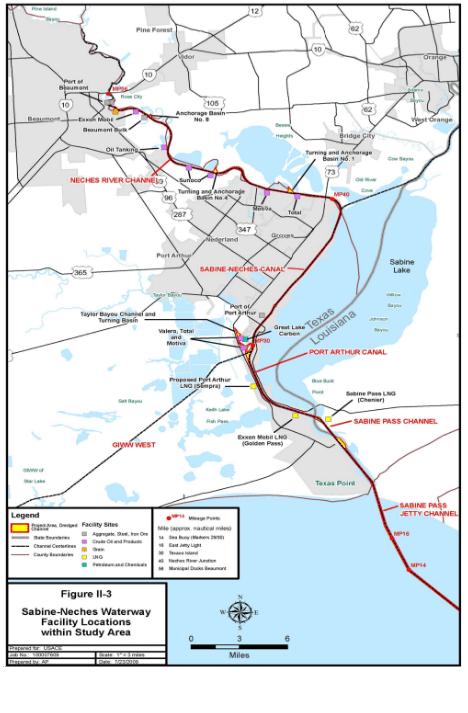
An initial array of project alternatives was identified during the screening analysis. The screening results were presented at the May 2001 Feasibility Scoping Meeting. For the screening, channel-deepening benefits were calculated for 43, 45, 47, 48, 50, 52, and 55 feet. The results showed that the 50-foot channel depth produced the highest net excess benefits. The results also showed that the net excess benefits for 50 feet were only slightly higher than for 48 feet. Incorporation of later traffic data and improved cost estimates continued to indicate that the maximum net excess benefits were in the 48- to 50- foot range. Channel deepening was proposed by industry as a means to allow the existing fleet to be loaded more fully, reduce per ton transportation costs for vessels using the waterway, and allow for reductions in the number of annual vessel trips.
Identification of the channel-widening alternatives was driven by physical structures along the Neches River and Sabine-Neches Canal and the Port Arthur Hurricane Protection Levee in the Sabine-Neches Canal reach. Delays prompted by transit restrictions are a major concern under existing conditions and will continue to be a concern under the without-project future. As part of plan formulation, the Neches River anchorage basins were introduced as an alternative to widening of the Neches River Channel.
The anchorages would be used to facilitate vessel passing. During the initial screening, extensive and intermittent widening was evaluated for the channel reaches from Sabine Pass Channel inland through the Neches River Channel. Widening of the Neches River was eliminated from consideration based on comparison of anticipated reductions in vessel delay costs and initial project construction cost estimates, and from the outputs of the Engineer Research and Development Center (ERDC) ship simulation modeling. Widening of the Neches River reach was found not be a cost-effective alternative due to the costs associated with dock relocations and extensive dredging.
The results of the ERDC modeling showed that a minimum width of 700 feet through the Sabine Pass Channel and Port Arthur Canal would be necessary for the Suezmax and Aframax vessels presently using the waterway to meet smaller vessels in the Sabine Pass Channel and Port Arthur Canal. Aframax tankers characteristically range from 90,000 to 120,000 dead weight tons (DWT), and Suezmax tankers characteristically range from 135,000 to 175,000 DWT. The project design vessel is an 899-foot- long, 164-foot-wide 158,000 DWT Suezmax crude petroleum tanker. ERDC testing of a 600-foot channel width alternative showed that neither a loaded or ballast design vessel was successful in meeting a comparably sized vessel, nor could the design vessel and a smaller 110,000 DWT Aframax tanker meet. In 2007, there were over 2,000 piloted vessels. The largest sized vessels using the channel to Port Arthur are Aframax tankers. The largest sized vessels using the Neches River Channel to Beaumont are Suezmax tankers. Sixty percent of piloted vessels shipped or received cargo from docks on the Neches River. Of the remaining 40 percent, 39 percent were associated with Port Arthur and the remaining 1 percent with the Channel to Orange.